
The Standby Signal No 1 will remain in force at least until 9 am on Sunday as tropical storm Kajiki will skirt around 500 kilometers to the south of Hong Kong while intensifying further, said the Hong Kong Observatory on Saturday.
The T1 signal, which was issued at 9:40 pm on Friday, means that a tropical cyclone now centered within about 800 kilometers of Hong Kong may affect us.
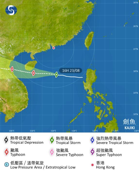
Kajiki was estimated to be about 530 km south of Hong Kong at 5 pm on Saturday and was forecast to move west at about 22 km per hour in the general direction of the seas south of Hainan Island, according to the observatory's bulletin issued at 4:45 pm.
"According to the present forecast, Kajiki will be closest to Hong Kong tonight (Saturday night), skirting around 500 kilometers to the south of Hong Kong while intensifying further," the HKO said, adding that Kajiki continued to move westwards steadily in the past few hours and occasionally strong winds started to affect offshore and high ground over the southern part of the territory.
ALSO READ: Typhoon Podul: HKO issues T1 signal, mulls T3 later
"Unless Kajiki undergoes rapid intensification significantly, or adopts a more northerly track, the Standby Signal No 1 will remain in force at least until 9 am tomorrow (Sunday)," the city's weather forecaster said.
The outer rainbands associated with Kajiki were affecting the waters south of Hong Kong, with a few squally showers and thunderstorms expected over the territory on Saturday night and Sunday, the observatory added.
With Kajiki moving inland and dissipating, showers will ease off gradually over the coast of Guangdong early next week, according to the HKO.