

Experts probe how climate warming may amplify Himalayan geological risks
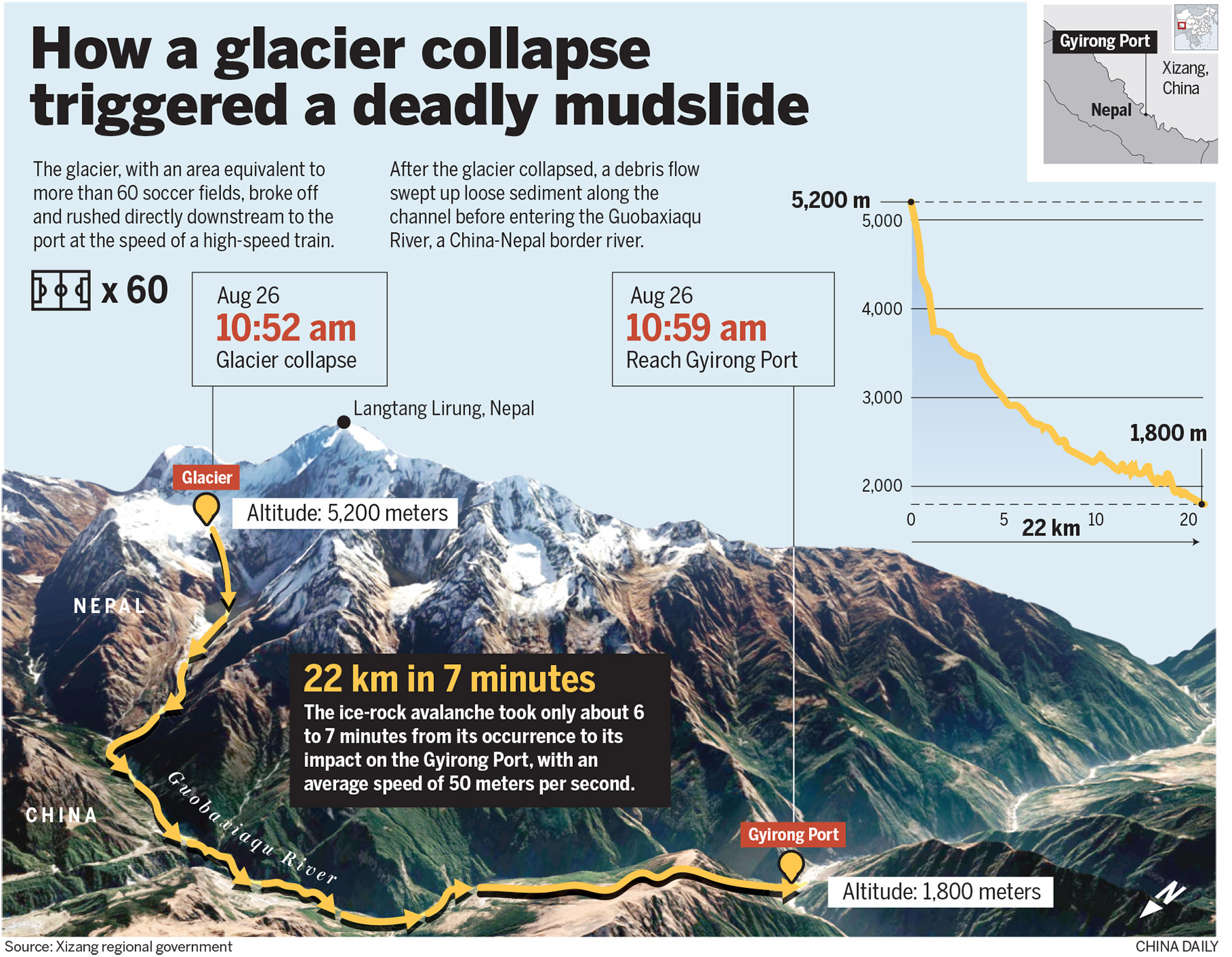
The collapse of a high-altitude glacier in Nepal triggered a deadly mudslide at a major China-Nepal border crossing. Experts said the underlying instability may be linked to a warming climate that is rapidly altering glaciers, permafrost and mountain slopes across the Himalayas.
The disaster occurred on Wednesday morning on the Nepal side of the border, sending a torrent of ice, rocks and debris toward Gyirong Port in Gyirong county, a major land crossing linking China and Nepal in Shigatse, Xizang autonomous region. The mudslide caused heavy casualties and left hundreds missing in China.
It was triggered by the collapse of a glacier at an elevation of about 5,200 meters on the southern slope of Langtang Lirung in Nepal. The glacier broke apart at about 10:52 am on Wednesday, triggering an icerock avalanche, the Xizang regional government said on Sunday.
READ MORE: High-altitude glacier collapse in Nepal triggered mudslide
The avalanche rapidly descended to an elevation of about 4,000 meters, scouring the mountain slope and generating a massive debris flow. It traveled 22 kilometers in seven minutes before reaching Gyirong Port, at an elevation of about 1,800 meters.
The disaster flattened about 0.7 square kilometers of the area and destroyed 27 buildings and associated facilities, authorities said.
The findings were based on an analysis of remote-sensing data and information transmitted from the disaster site, combined with field inspections and interviews conducted by a cryosphere emergency disaster mitigation team from the Chinese Academy of Sciences' Institute of Mountain Hazards and Environment in Chengdu, Sichuan province.
Xu Qiang, president of Chengdu University of Technology, said the disaster's extreme destructive power was driven by geological factors, including the huge elevation drop of more than 3,000 meters.
The massive volume of debris and the sudden onset of the collapse also left little time for warning or response, Xu said.
The US Geological Survey similarly found that the disaster was likely triggered by a rapid slope failure involving a glacier in the Langtang National Park in Nepal.
Ben Mirus, a research geologist with the USGS, said glacier collapses combined with debris avalanches are relatively uncommon, but large landslides and rockfalls can cause devastating damage.
However, while scientists have identified the immediate mechanism, they have yet to determine why the glacier and surrounding rock became unstable and collapsed at that particular moment.
"It's really hard to attribute the exact trigger for this particular glacial collapse," Mirus said.
According to local meteorological data, there was no heavy rainfall near the outlet of the debris flow at the time of the disaster, making it unlikely that intense rainfall alone could explain the event.
Fan Xuanmei, director of the State Key Laboratory of Geohazard Prevention and Geoenvironment Protection at Chengdu University of Technology, said that, based on current evidence, the collapse was likely the result of a combination of the region's geological setting and a warming climate.
The Himalayas are located along the collision boundary between the Indian and Eurasian tectonic plates. Continued tectonic activity has fractured mountain rock and contributed to frequent earthquakes, leaving slopes vulnerable to failure.
"Against this long-term tectonic backdrop, climate warming is acting as an important 'amplifier'," Fan said.
She added that rising temperatures are accelerating the melting of snow and ice, intensifying freeze-thaw weathering of rock and reducing the stability of snow cover and glaciers, "thereby increasing the likelihood of large-scale avalanches, glacier collapse and rockfalls".
As glaciers retreat, they can also expose and leave behind large quantities of loose rock and sediment that can later be mobilized by a collapse, she said.
Since the Industrial Revolution, the world has warmed by about 1.4 C, according to the Copernicus Climate Change Service.
China Meteorological Administration data shows that the Qinghai-Tibet Plateau's average temperature increased by 0.37 C per decade between 1961 and 2022, faster than global and national averages.
The changing climate is also affecting the region's water systems. The area of lakes in 12 major river basins on the plateau increased 36.7 percent from 1990 to 2020, according to the administration.
Experts warn that these changes can create interconnected hazards rather than isolated disasters.
"Detecting such failures before they occur is extremely difficult," Fan said.
Potential source areas are often above 5,000 meters, where conventional field monitoring is difficult. Satellite observations can be limited by snow and ice cover and steep terrain, while monitoring equipment has to operate in extreme cold and high-altitude conditions.
"We also lack mature models capable of reliably predicting the complete chain from glacier or rock collapse to debris flow, mudslide and downstream flooding," she said.
The disaster also revealed gaps in cross-border monitoring. The debris flow reached China from the apparent source in Nepal within minutes, leaving little time for information to be transmitted to communities downstream.
ALSO READ: Rescue teams intensify searches in Gyirong
"After the disaster, we immediately contacted experts in Nepal, but they also lacked data from relevant weather stations to confirm the conditions at the site," Fan said.
The changing Himalayan environment has made cooperation increasingly important, experts said.
China and Nepal could jointly build high-altitude meteorological and hydrological monitoring stations, share satellite remote-sensing and seismic data and establish rapid cross-border disaster notification mechanisms, Fan said.
Such efforts could also expand across the Himalayas, bringing together China, Nepal, India, Pakistan and international research institutions to develop shared monitoring networks and early-warning technologies, she added.
Contact the writers at zhaoyimeng@chinadaily.com.cn
