
The Hong Kong Observatory issued the Gale or Storm Signal, No. 8 on Sunday night as tropical cyclone Tapah intensified and edged closer to the city.
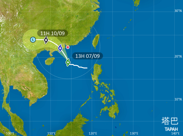
The HKO raised the T8 typhoon warning signal at 9:20 pm after Tapah intensified into a severe tropical storm and was forecast to skirt within 200 kilometers southwest of Hong Kong around sunrise on Monday.
The T8 warning meant winds with mean speeds of 63 kilometers per hour or more were expected as local winds were forecast to strengthen further due to Tapah.
“It will then make landfall over western Guangdong. The Gale or Storm Signal, No. 8 will remain in force at least until 11 am tomorrow morning,” the observatory said.
"Unless Tapah adopts a track closer to the Pearl River Estuary or intensifies significantly, the chance of issuing higher tropical cyclone warning signals is relatively low," it added.
Day classes suspended
The Education Bureau said in a statement that classes in all day schools, including secondary schools, primary schools, special schools, kindergartens, and kindergarten-cum-child care centers, are suspended on Monday.
ALSO READ: HKO: Tropical cyclone to skirt 200km around HK Monday morning
At 9 pm Sunday, Tapah was centered about 250 kilometers south-southwest of Hong Kong and was expected to move northwest or north-northwest at about 18 kilometers per hour, edging closer to the western coast of Guangdong.
The observatory had raised the Strong Wind Signal, No. 3 (T3) at 2:40 am on Sunday due to the approaching typhoon.
"Locally, there will be squally heavy showers and thunderstorms tonight and tomorrow. Seas will be very rough with swells," the observatory said.
It urged members of the public stay away from the shoreline and avoid water sports, adding that flooding may occur over parts of low-lying coastal areas on Monday morning due to the storm surge.