
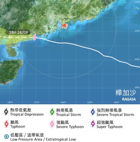
The No 8 southeast gale or storm signal will remain in force until 8 pm on Wednesday as Severe Typhoon Ragasa was departing from Hong Kong and had made landfall over Yangjiang in western Guangdong province, the Hong Kong Observatory said.
"Local winds are weakening progressively, but gale force southeasterly winds are still affecting parts of the territory. Winds occasionally reach storm force offshore and on high ground," the observatory pointed out in a bulletin.
The intensity of Ragasa – described as the world’s strongest tropical storm so far this year – had also reduced from super typhoon to severe one, according to the HKO.
The observatory said it will consider issuing the strong wind signal No 3 depending on the extent of weakening of local winds.
At 6 pm, Ragasa was centered about 250 km west-southwest of Hong Kong and was forecast to move west at about 22 km per hour, skirting the coast of western Guangdong and weaken gradually.
The amber rainstorm signal was issued again at 3:20 pm, indicating that heavy rain had fallen or was expected to fall generally over Hong Kong, exceeding 30 millimeters in an hour, and is likely to continue. The alert was first hoisted at 2:45 am and cancelled at 11:50 am.
"Hourly rainfall was expected to exceed or had exceeded 70 millimeters over North District and Tai Po District and 140 millimeters over Sai Kung District," the observatory said.
There will be occasional squally showers and thunderstorm later Wednesday and on Thursday as Ragasa's outer rainbands will still affect the coast of Guangdong, the weather forecaster warned.
ALSO READ: Classes, flights suspended as Super Typhoon Ragasa approaches
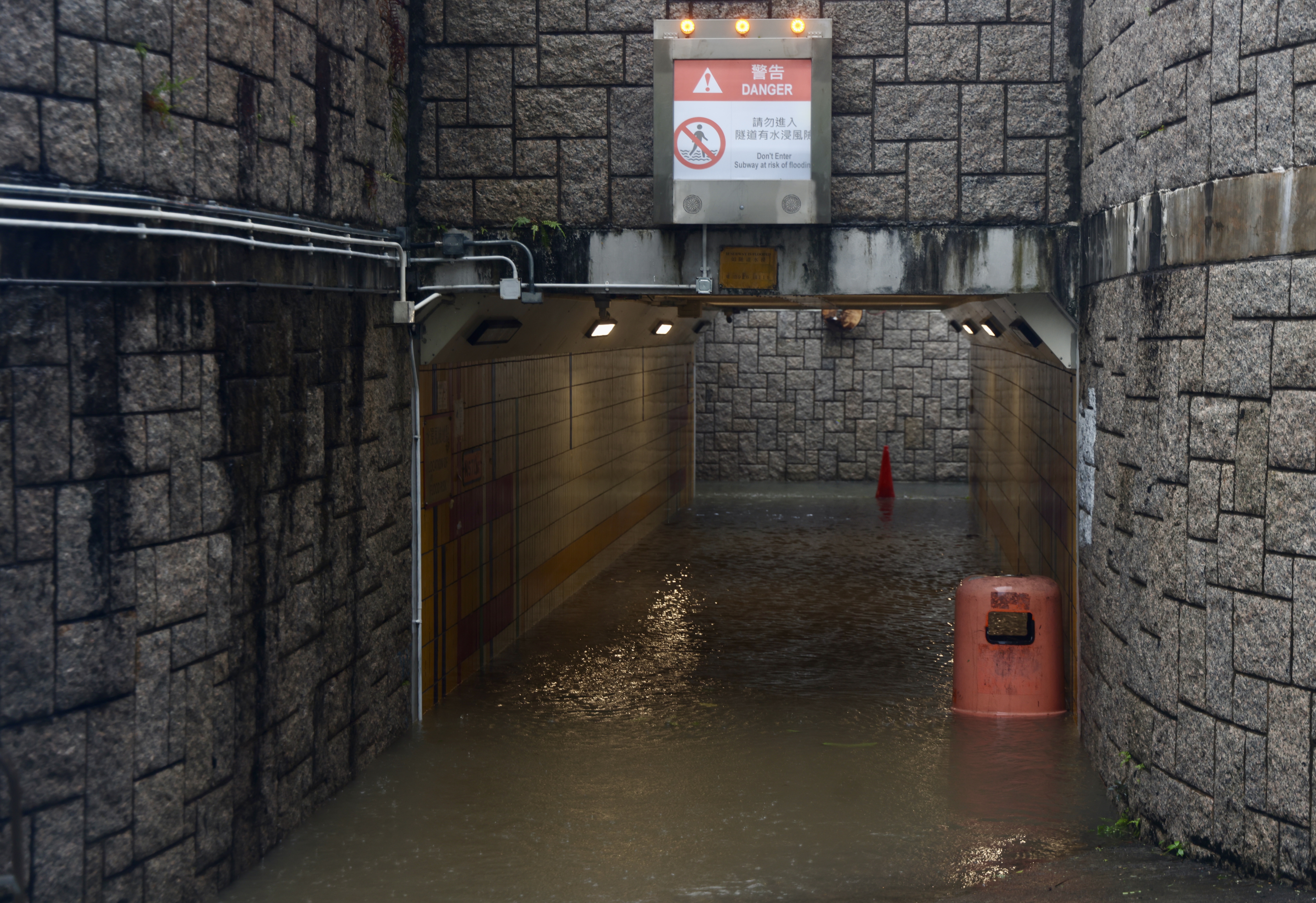
Meanwhile, the landslip warning and the special announcement on flooding in northern New Territories had been issued.
With Ragasa departing further and weakening, the weather will improve with showers easing off gradually in the latter part of this week, the observatory added.
Second longest-lasting time
The observatory raised its highest storm warning No 10 at 2:40 am after the typhoon forced most businesses and public services to shut down. It was the second time the hurricane signal as gone up this year after Typhoon Wipha struck in July.
Downgraded to No 8 at 1:20 pm, the No 10 signal for Ragasa had lasted about 10 hours 40 minutes - surpassing the lasting time during Typhoon Mangkhut in 2018 and second only to an 11-hour record set by Typhoon York in 1999 - making it one of the longest-lasting storm signals in that category in the city's meteorological history.
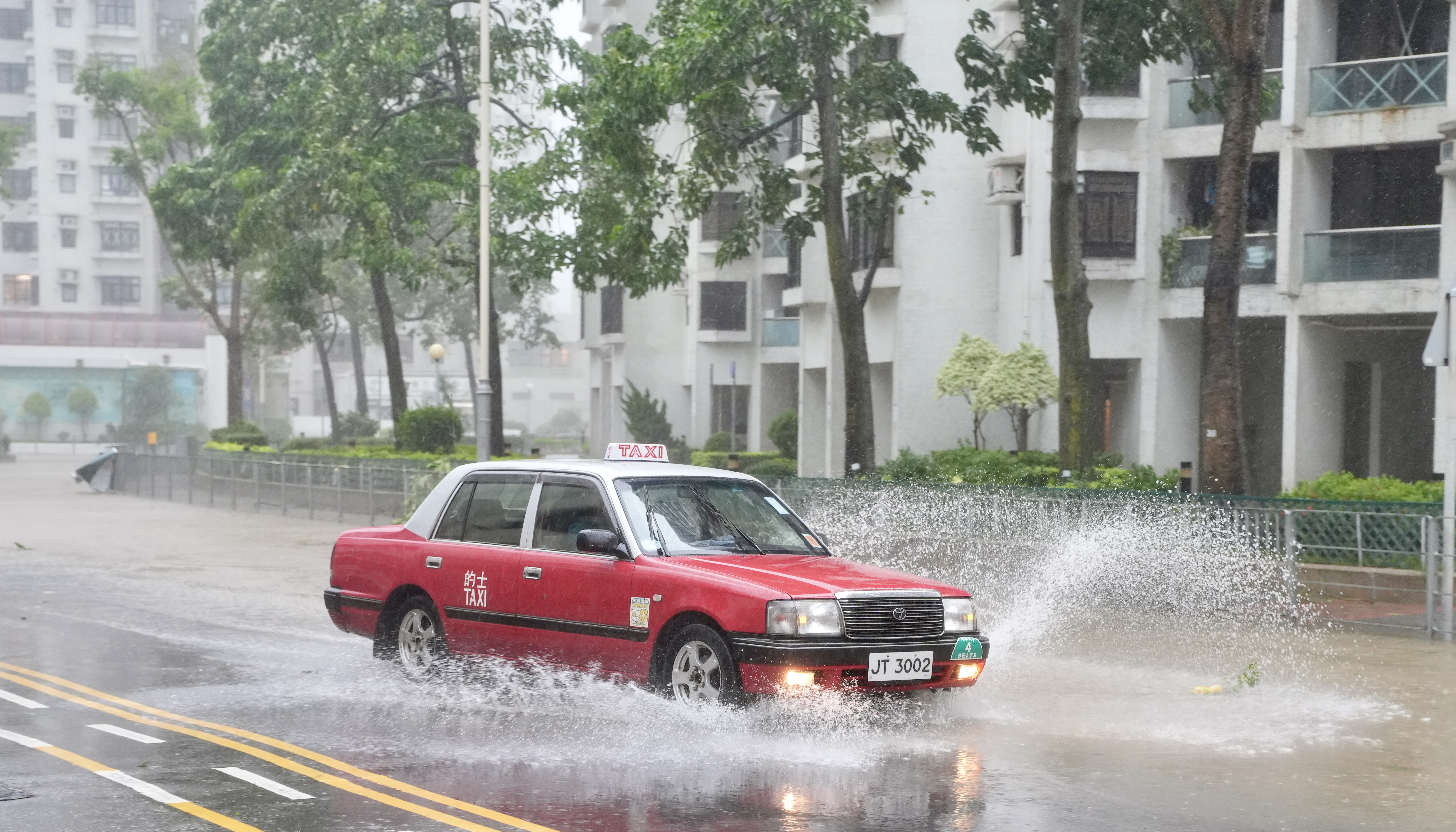
Strong winds and heavy showers lashed most parts of the city in the early hours of Wednesday as Ragasa came close to within 100 km south of the territory.
ALSO READ: HK races to fortify coast as Super Typhoon Ragasa nears
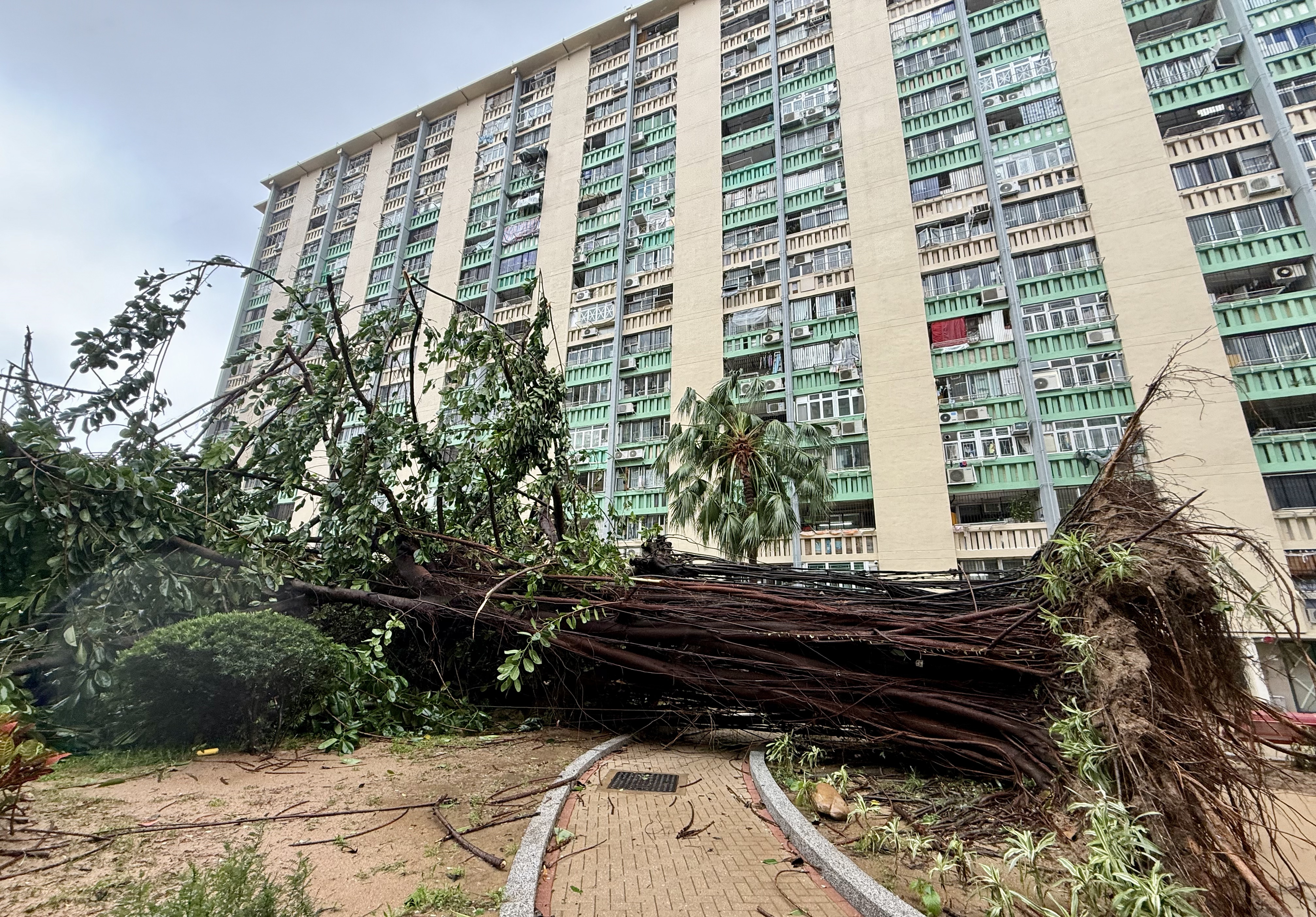
Uprooted trees, flooding, landslips
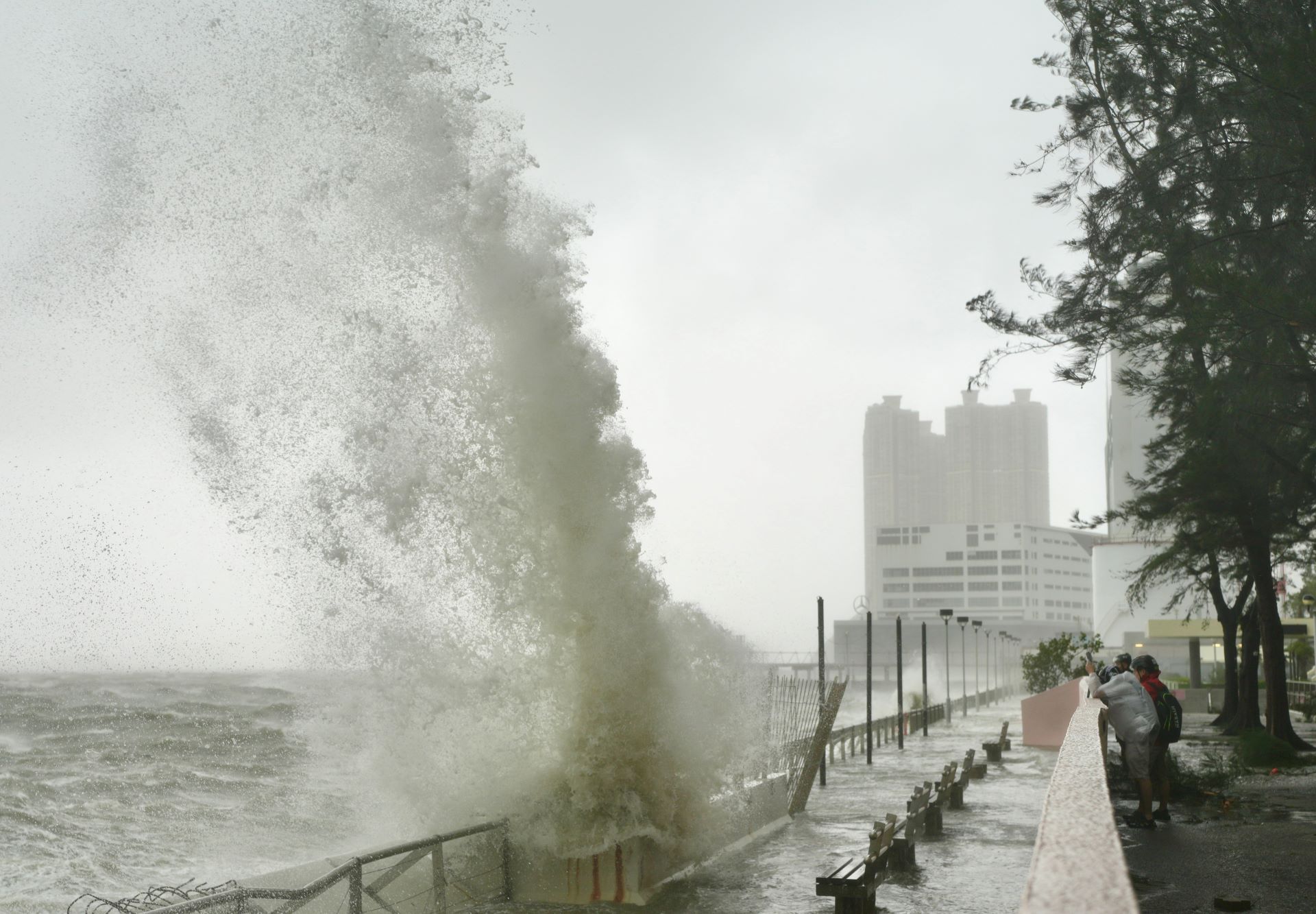
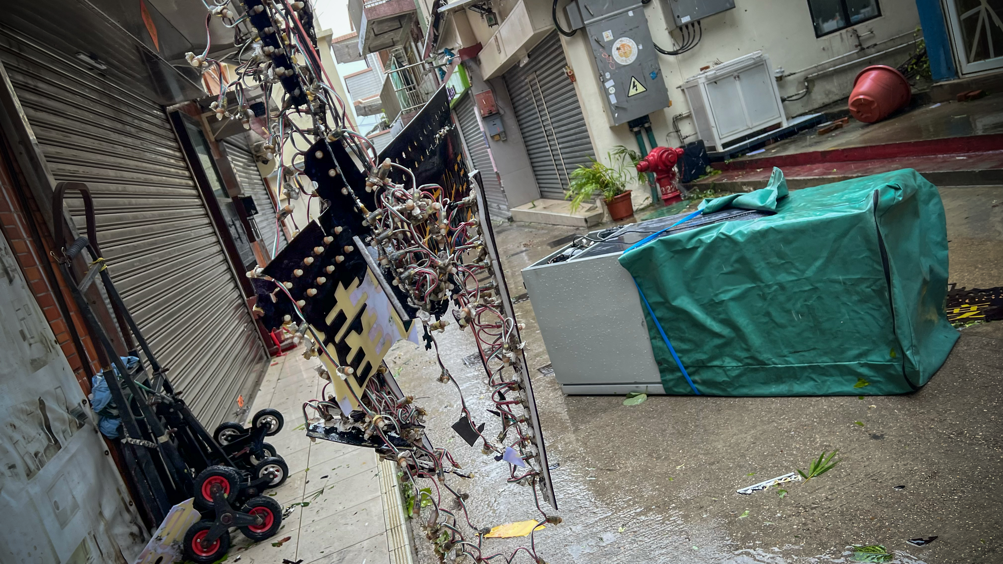
Hong Kong woke up to Ragasa’s wrath, with hurricane-force winds uprooting trees, setting containers and a barge ship adrift, and flooding a hotel, seaside parks and restaurants.
The storm’s fury was starkly visible in Tseung Kwan O as social media footage captured deluges along the district’s waterfront promenade. The disruption extended to Tong Chun Street – a key thoroughfare in the Tseung Kwan O town center – where a toppled tree had blocked the road.
Local media also reported the police were alerted at about 7 am that a shipping container, suspected to have been blown away by violent gusts, had been left adrift in the sea near a residential block, sparking fears that people had been trapped. However, no casualties were reported.
The rapid deterioration in the weather overnight also left streets partially submerged and hundreds of residents seeking shelter.
As of 3 pm, 16 reports of flooding and 700 cases of fallen trees had been received. The severity was evidenced by social media footage, including a clip showing seawater surging into the lobby of The Fullerton Ocean Park Hotel in the Southern District. The hotel’s management assured that the safety of guests and its staff remained its top priority, and there have been no injuries.
Another video showed a barge set adrift by high winds, subsequently against with the shoreline in Hung Hom.
As of 3 pm, 869 people had sought refuge at 50 temporary shelters across the city. The Hospital Authority said 82 people -- 47 men and 35 women – had been treated at public hospitals for typhoon-related injuries.
The Geotechnical Engineering Office said on social media three landslips had occurred in Sai Ying Pun, Tuen Mun and Stanley as of 4pm. Two of them involved uprooted trees, damaging slopes and retaining walls.
Residents have been warned to steer clear of the slopes due to possible further landslides.
Transportation
Mass Transit Railway Corp said on Wednesday afternoon subway services will gradually resume, and those on the Tsuen Wan Line, Kwun Tong Line and Island Line, as well as the “Tsuen Wan West - Diamond Hill” section on Tuen Ma Line had been fully restored.
Full subway train services on the South Island and Tuen Ma lines have resumed followng the downgrading of the No 10 hurricane signal to No 8.
The operator had maintained only limited train services for underground sections during the hoisting of typhoon signal No 9 or higher.
However, it said it would take some time for services on open-air sections to return to normal due to obstacles like uprooted trees and cable failures on the tracks. Services on the East Rail Line's cross-boundary sections from Tai Po Market to Lo Wu and Lok Ma Chau, as well as on multiple sections of the Light Rail system in Tuen Mun, will remain suspended.
Services on these routes are not expected to be restored until late Wednesday evening, pending the completion of repair and cleanup works.
High-speed railway services will remain closed for the rest of Wednesday.
Family rescued
During the super typhoon, three members from a family were rescued after falling into the sea near Chai Wan, the Hong Kong Police Force said on Tuesday.
The family of four was watching waves from a breakwater when the mother and the 5-year-old son were swept into the sea. The father jumped in immediately in an attempt to rescue them.
Boatmen nearby helped pull the three from the water before firefighters arrived on the scene and took them to the hospital.
The mother and the boy were hospitalized in an unconscious but stable condition. The father remained conscious.
READ MORE: Macao lowers storm surge warning from red to blue as Ragasa moves away
In Macao, where the No 10 signal was issued at 5:30 am, the city too faced a significant threat from surging waters, particularly around the low-lying Inner Harbor area on the peninsula’s west coast. The Macau Electricity Company has suspended power to parts of the area, saying it would be restored once the weather improves.
With Xinhua’s inputs
Contact the writer at wanqing@chinadailyhk.com